How Buyers Evaluate Canals In Lighthouse Point
May 7, 2026
May 7, 2026
If you are shopping waterfront in Lighthouse Point, the canal behind the home may matter just as much as the house itself. Two properties can look similar online, yet offer very different boating access, bridge constraints, wake exposure, and maintenance considerations. If you want to buy with confidence, it helps to evaluate each canal the way experienced waterfront buyers do. Let’s dive in.
Lighthouse Point is not just a beach-area city with a few waterfront streets. It is a compact, almost fully developed city with about 18 miles of man-made, bulkheaded waterways, and the Intracoastal Waterway runs the full length of the city. Many homes front the water, so buyers are often making micro-location decisions instead of broad neighborhood decisions.
That distinction matters because the canal is part of your daily use of the property. In Lighthouse Point, waterways function as both lifestyle features and public infrastructure. The city regularly maintains canals and storm drains, and it also has a Marine Patrol Unit focused on boating safety education and marine law enforcement.
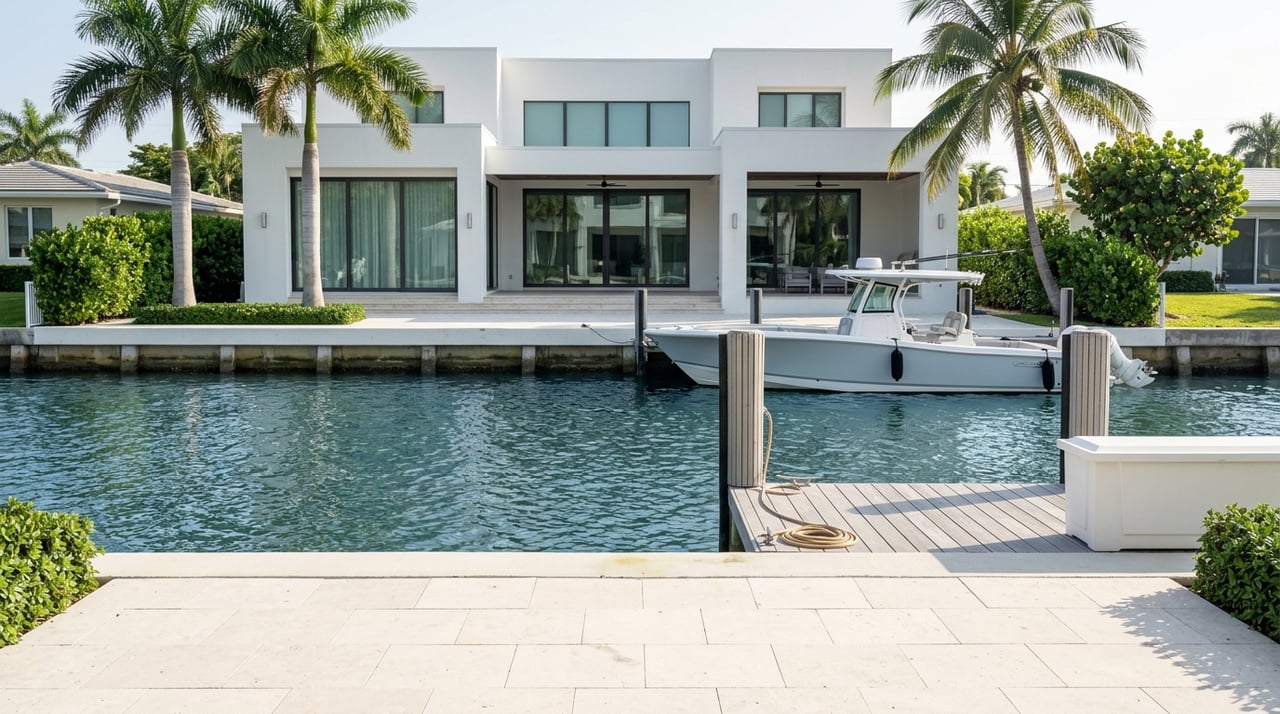
For most waterfront buyers, the first question is simple: Does this canal fit the boat and the way you plan to use it? A home can have a beautiful dock and water view, but still be a poor match if your route to the Intracoastal or inlet is too restrictive.
The city’s dredging documents provide useful baseline measurements. Lighthouse Point has identified maintenance dredging to a depth of -5.0 feet below mean low water and a typical channel bottom width of 40 feet. Canal work areas are accessed through the Intracoastal Waterway, which reinforces how route planning connects directly to day-to-day boating.
In Lighthouse Point, one block can differ from the next. City newsletters show dredging is phased by canal segment, and recent updates listed some canals as completed while others remained pending, including areas near the south side of the Sample Road Bridge.
That means you should evaluate the specific canal segment behind the property, not just the street name or the fact that the home is marketed as waterfront. Conditions can vary even within the same general area.
For buyers who want quick access to open water, Hillsboro Inlet is the key outlet nearby. NOAA notes that the inlet connects with the Hillsboro River and the Intracoastal Waterway and is important for boaters heading toward the Gulf Stream.
But route planning is not just about distance. NOAA also reports that the A1A bridge at the inlet has a 13-foot bascule clearance, and flood tide current near the bridge can reach 5 to 6 knots. In practice, the last stretch of your run may be the most limiting part of the trip.
A canal may look ideal on a map, but the bridges along your route can quickly narrow your options. If your vessel has notable height, bridge clearance should be one of your first filters.
NOAA provides a bridge air-gap system that updates every six minutes to help mariners assess clearance. In a city like Lighthouse Point, where bridge crossings affect both roadway access and boating routes, this data can be especially useful during due diligence.
Lighthouse Point has adopted a Bridge Replacement Master Plan that prioritizes the Sample Road Bridge, the NE 31st Court Bridge, and several other crossings over local canals. The city has also noted that Sample Road Bridge serves as a single point of access and hurricane evacuation route to Lake Placid, while NE 31st Court Bridge is the sole access point to a 25-lot residential island.
For buyers, this is a reminder that bridge conditions do not affect only boats. They can also influence how you enter and exit a section of the city by car.
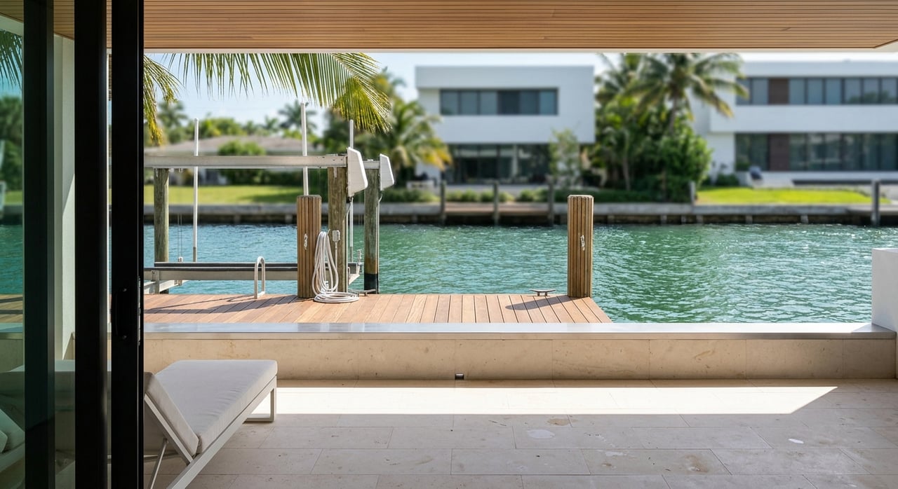
Distance to the Intracoastal is important, but so is what the canal feels like on a normal day. Some buyers prefer a quieter setting with less pass-through activity, while others prioritize a more direct route and accept more movement on the water.
Florida boating rules define idle speed and no wake as the minimum speed needed to maintain headway and steerageway, without creating an excessive or hazardous wake. Since Lighthouse Point’s Marine Patrol enforces marine laws and promotes boating safety, wake is more than a comfort issue. It is part of how the city manages its waterways.
In practical terms, buyers often compare busier connector waterways with quieter spur or dead-end canals. That is not a zoning label. It is a real-world difference you may notice based on how the canal links into the broader waterway network.
If you value a calmer dock setting, spend time observing the canal at more than one hour of the day. A showing at mid-morning may feel very different from a weekend afternoon with more boating traffic.
Not every canal-front property lives the same way. In Lighthouse Point’s built-out grid of homes and waterways, the direction a property faces can shape light, breeze, privacy, and your sense of activity on the water.
The city describes Federal Highway as the west door and the Intracoastal Waterway as the east door, and the canal system runs through a dense residential layout. Because of that pattern, east-west and north-south canal exposure can create noticeable differences in morning sun, afternoon heat, and how directly boats pass your dock.
This is one of the most overlooked parts of waterfront shopping. Aerial images can help, but they do not fully capture glare, breeze, dock usability, or how private the rear yard feels.
If possible, visit the property more than once. Seeing the canal in early morning, late afternoon, and on a busier boating day can tell you much more than listing photos alone.
In Lighthouse Point, flood review should happen early, not at the end of the process. The city’s flood information states that FEMA flood maps are available and elevation certificates can be requested from the Building Department.
The city’s comprehensive planning materials also say a large portion of Lighthouse Point is subject to 100-year flood conditions, with the western portion subject to 100- to 500-year flood conditions. The city has also received Resilient Florida Program funding for a vulnerability assessment and adaptation plan.
For canal-front buyers, flood and marine infrastructure should be reviewed together. Elevation, insurance considerations, and seawall condition all affect long-term ownership.
A beautiful lot and a good boating route may still require careful analysis if the seawall is aging or if you are planning improvements. Looking at these items as one package gives you a more realistic picture of ownership costs and future work.
If you plan to update a dock, rebuild a seawall, or make major marine improvements, do not assume the work will be simple. Lighthouse Point requires permitting, and the city’s checklist notes that plans may also need approval from Broward County, DEP, or the Army Corps.
The city also requires an updated dock and seawall survey before final inspection. In other words, you want to know what is already permitted, what may have been grandfathered, and what changes could trigger a new review process.
A smart canal-front review often includes questions like these:
These questions help move the decision from a general waterfront dream to a more precise ownership plan.
The strongest Lighthouse Point canal search usually starts before a private showing. Public information can help you narrow the right streets and canal segments based on your boat, route preferences, and tolerance for wake and bridge limits.
Useful sources mentioned by the city and NOAA include the city map, the 2022 Hydrographic Survey link, NOAA Coast Pilot materials, tide station data for Hillsboro Inlet, bridge air-gap tools, and city bridge project pages. Together, they help you evaluate depth, clearance, route conditions, tides, and access patterns in a more informed way.
In Lighthouse Point, canal shopping is rarely just about the view. It is a geometry, access, and livability decision wrapped into the home purchase. Two waterfront homes can offer very different experiences depending on canal segment, bridge profile, wake exposure, orientation, and flood or permitting considerations.
That is why a careful buyer looks beyond the listing photos and asks how the property will function in real life. If you want help comparing canal-front options in Lighthouse Point with a sharper eye for boating access, property fit, and waterfront value, connect with Maria Montalbano for a private consultation and personalized market review.


What Buyers and Sellers Need to Know About the Fort Lauderdale Real Estate Market Right Now.

A Complete Guide to Preparing to Sell Your Home in Fort Lauderdale Before the Sign Goes Up.

A Seller's Guide to the Home Selling Process in Fort Lauderdale From Contract to Close.

What Sellers Need to Understand About Buyer Psychology When Selling Your Home in Fort Lauderdale.
If you are relocating to South Florida, let me know the needs of your ideal real estate purchase, and my team and I will conduct in-depth market research to prepare the properties for your viewing upon arrival or virtual showing.